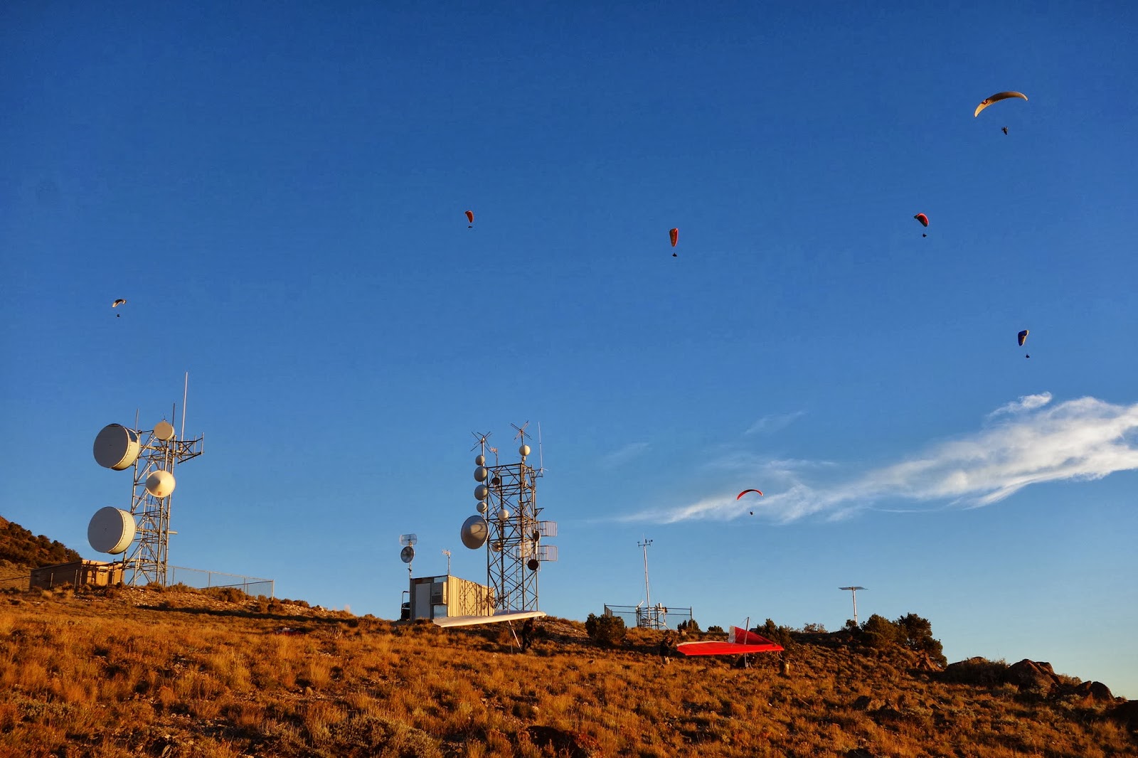
A great fall escape down to Richfield back in late September for the Red Rocks Fall Fly-In. Organized by Stacy Whitemore of www.cuasa.com, who pioneered a lot of the launch sites in Central Utah. We had some wonderful flying over the beautiful fall colors!
Dawn - Sometimes An Ultrarunner

December 5, 2013
November 30, 2013
Iquique Chile Paragliding Tour Participants Break XC Records
 We were nearing the end of our three week paragliding tour to Iquique, Chile. The beginners had come and gone the first week, making great strides in their learning and confidence. Those of us staying the whole time were almost sated with flying, having gotten as much airtime everyday as anyone could have wished for.
 But we were still hungry. For some distance. Several times we had made an attempt to fly our way up the coast. Each time we were grounded, due to circumstances and cross winds, rotor over the difficult sections.
It was our last day to do some cross country flying. It looked good as we drove up to launch. Higher cloudbase than previous days, light SW winds, and a feeling in the air that this would be a good day.
 Eleven of us launched together, sending the drivers down the long road back to the ocean. It was a struggle and a wait for everyone to thermal up to cloudbase, but for a short time all of us were moving down the ridge together.
 The vans made it back down the sand roads to the ocean as a pilot here or there began to call it a day. The rest of us carried on, letting the air currents pull us up and over and around the never-ending sandy hills that are northern Chile. The red, orange and white ridge was monotonous and beautiful at the same time, offering up dunes and dry river beds; mining holes and stray cactus; soaring buzzards and an endless supply of sand.
 I was flying a new wing this tour, having virtually worn out my sturdy orange and blue wing. This one was green and blue, looking like eagles eyes, making me happy when I looked up at it.
I started ticking off distance on my GPS. 20 kilometers, then 40, then 60. Dare we hope to make that elusive 100? At midday the thermals got stronger. We paused to let the vans check a difficult crossing...the winds were our friend and we flew around the point without issue.
Then I was into new territory. Our guides were above, behind, below, and ahead of us, checking for lift and ensuring a safe line through tricky sections. The ridge got lower, making a loss of altitude more likely to put us on the deck. The wind got stronger, forcing us to stay further away from the venturi winds on the ridgetops. We didn't care...we got high, higher than we had been all day, and carried on at three thousand feet above the ocean. By then we were just five small wings in a big sky. I tried to keep everyone in sight, and stay high.
 A couple last tricky sections. By then I knew nothing was going to stop me from reaching the goal...a beach landing in front of my hotel, and the longest XC flight of my life. But the graveyard still beckoned...a section that has put so many pilots on the ground it has a name, a life of its own. I start over it high, plenty of altitude. Or so I thought. Sink, then more sink. Crap. Time for full speed bar, the sand dunes which can save me still a long ways away.
 I hit the dunes with barely seven hundred feet of altitude. The winds are changeable, ripping up the slope and bouncing me all over. At one point I have my feet out ready to land, I'm that close to the ground. I don't dare go away from the hill or I'll sink out completely. Slowly, slowly, I start working my way back up the hillside. The others wait for me, confident that I'll make it back up

The vans race ahead of us to check for whitecaps on the ocean around the last point before the town comes into view. I don't care what they see, nothing is going to stop me from making the last turn and heading to the beach. We fly over the golf course, which in this parched land is nothing more than white lines painted around more blankets of endless sand. I think each fairway looks like dirty socks laid out to dry in the sun. But I'm not concerned with that now.
 The ripping thermals quiet all of a sudden as we see the town. The lift softens and we make gentle turns up into the blue sky. No longer do we need to hug the hillsides, and from three thousand feet we head straight for our beach over the open ocean. The air is soft now, and we can shout, laugh, and take photos of our wings bright over the blue water. Ken and I carefully bring our wings close together and bump wingtips. We look down and see seals playing in the water below us.
The beach comes closer and I wiggle stiff legs and fingers, get ready to touch the earth again. I'm not ready, but the earth is ready for me. My legs wobble, my head bobs like I'm flying a spaceship, and I'm grinning from ear to ear. We've been in the air for 5 hours, and suddenly I'm thirsty.
 |
| Left to Right: Luis Rosenkjer, Jim Sorensen, Ken Hudonjorgensen, Dawn Westrum, and Todd Weigand |
See our whole route here at XContest
Thanks to Ken, Luis and Todd for giving Jim and Dawn the chance to do the longest XC of our life!
Thanks to Todd for coming through with the great photos...of course my camera picked this day to have a dead battery!

 |
| Tracklog from a part of the flight. Green lower elevation, red is higher. |
 |
Our whole 121 Kilometer route as seen on XContest.org |

October 22, 2013
Fly Camping in Central Utah
 So I enjoy camping, and I enjoy paragliding, and a very
small niche of people have started combining the two into a sport called Fly
Camping. Or “Vol Biv” in French, which
sounds a bit more exotic. In other
words, you carry everything you need to camp in your harness, and then after
you fly somewhere, you land on a mountaintop, camp for the night, and fly off
again the next day. Finding the right
weather for paragliding two or more days in a row is the key…getting stranded
on a mountaintop and having to walk down is kinda a buzzkill.
So I enjoy camping, and I enjoy paragliding, and a very
small niche of people have started combining the two into a sport called Fly
Camping. Or “Vol Biv” in French, which
sounds a bit more exotic. In other
words, you carry everything you need to camp in your harness, and then after
you fly somewhere, you land on a mountaintop, camp for the night, and fly off
again the next day. Finding the right
weather for paragliding two or more days in a row is the key…getting stranded
on a mountaintop and having to walk down is kinda a buzzkill.
I suppose this could be combined with Hike and Fly, which is where you hike up a mountain to launch your paraglider. But by adding all the gear for camping, your pack gets rather heavy so you may want to pick a smaller mountain to launch from than normal!
So I'm getting my gear together to do some Vol Biv, although it is rather late in the season and winter is approaching. But there are a few chances left this year, and I was just down at the Red Rocks Fly-In for an informal pilot get together. The weather was warm right when I arrived, so I took an opportunity to do some combined flying and camping right away. On the first afternoon of the Fly-In, we headed up to Cove Launch southeast of Richfield for an afternoon glass off. I had my brand new Advance Lightness Pod harness packed with all of my camping gear, namely tarp, sleeping bag, sleeping mat, food, stove and flashlight, among other small things. It was stuffed...but still almost lighter than other harnesses I've flown empty!
 The afternoon wind was strong and we launched quite late. I soared high above launch and decided that the best place to camp (and the safest for my first try) was launch itself, which had a large area where I could top land, and then perhaps fly with the group again in the morning if they came up for a morning sled ride. So although it wasn't very purist, I top-landed on Cove while there were still vehicles and a few pilots on launch. They finally left and I was alone on the mountain, under darkening starry skies and light winds. It was quite warm and the stars were brighter than anything I'd seen lately.
  My camping kit kept me quite warm for the night, although lacking a tent it did get a little chilly. So I pulled my wing over me and used the insulation from the fabric to add a few degrees of warmth. My camp was a little rocky under my thin sleeping mat...I had chosen it in the near dark and preferably I would search a little more in the future!
The next morning was clear and bright and a little windy, but it died off to nothing. I didn't want to wait all morning for the thermals to start up, so I just took a sled ride down to the landing zone where my car was waiting for me. Perfect! I'm heading to Iquique, Chile in a few weeks, and I'm gonna try it again there...at least down in the desert I don't have to worry about getting rained on!


October 4, 2013
Snow Camping Weekend
 Another weekend and another camping trip snuck in before winter arrives...maybe. This time with my nephew Aidan who was
excited to get out on his first backpacking journey ever. We decided to head back up to the Uinta
Mountains again, this time to the western side because it was an easy drive
from the SLC valley.
Another weekend and another camping trip snuck in before winter arrives...maybe. This time with my nephew Aidan who was
excited to get out on his first backpacking journey ever. We decided to head back up to the Uinta
Mountains again, this time to the western side because it was an easy drive
from the SLC valley.
The weather looked clear and calm starting Friday evening
through Sunday morning. There was a
weather system coming through Thursday and Friday but it looked like it would
clear out on time for us, luckily. What
I wasn’t counting on was the possibility of snow!
 I picked Aidan up from school in the afternoon; we were
already packed up and ready to head out.
It was windy and chilly, and flurries started falling on us on the drive
up to Park City. It certainly didn’t
look like a good evening to camp but Aidan was still excited and I was counting on
the weather forecast coming through for me.
I picked Aidan up from school in the afternoon; we were
already packed up and ready to head out.
It was windy and chilly, and flurries started falling on us on the drive
up to Park City. It certainly didn’t
look like a good evening to camp but Aidan was still excited and I was counting on
the weather forecast coming through for me.
As we headed up the Mirror Lake highway, the snow kept
flurrying and then began accumulating on the ground. Our trailhead was at 10,000 feet…by the time
we drove into the High Line Trailhead, there was 6 inches of white stuff on the
ground!?!?! I had some misgivings about
setting off in winter weather but decided my backpacking gear could handle it. Luckily we were all packed up, and with a
quick change of clothes we left the car and headed out into the forest.
It was already late, so for our first camp we only walked as
far as the first lake on the trail, a couple of miles into the falling
snow. It got less and finally stopped as
we hiked, and kicking through the fluffy stuff was actually kind of fun. Getting our feet wet in the straggling mud
puddles was not. Aidan asked me how
many times I had gone winter camping…I had to laugh as I said it was my first
time ever! We set up camp with cold
fingers and toes, but cooked a hot supper and were warm and dry in the tent
playing Yahtzee by full dark. Well,
almost warm…cold feet lasted quite a while into the night.
 We woke up to bright sunshine and a winter wonderland…an
amazing view of fluffy snow tucked into every crevice in each tree branch. And our hiking that day was equally
amazing. Night had frozen the mud puddles,
more or less, but under blue skies it didn’t take long to start melting
everything. Snow clumps fell from
trees, and by late afternoon the snow had melted from everywhere but under the
deepest tree cover. Aidan and I hiked
slowly through the trees, didn’t try to get anywhere, and enjoyed breaking the
ice in the mud puddles.
We woke up to bright sunshine and a winter wonderland…an
amazing view of fluffy snow tucked into every crevice in each tree branch. And our hiking that day was equally
amazing. Night had frozen the mud puddles,
more or less, but under blue skies it didn’t take long to start melting
everything. Snow clumps fell from
trees, and by late afternoon the snow had melted from everywhere but under the
deepest tree cover. Aidan and I hiked
slowly through the trees, didn’t try to get anywhere, and enjoyed breaking the
ice in the mud puddles.
We set up camp in Naturalist Basin quite early in the day,
giving us time to even dry a pair of wet socks and the tent, and play some more
dice games. This time we were able to
kick the snow from under the tent and get down to grass, keeping us warmer for
the night and more comfortable.
The tent was frozen again with condensation in the morning,
when I rousted Aidan out of bed before the sun came up for an early start. It was below freezing, the puddles were
frozen again, and even after a hot breakfast our feet stayed cold on the hike. We headed all the way out to the car, making
the 7 miles in about 3 hours without much of a break. Aidan was a trooper, though, and kept his
feet moving down the trail. What a cool
first backpacking trip! Thanks for going with me Aidan!


 |
| Breaking holes in the ice puddles with our trekking poles! |


September 28, 2013
Uinta Marathon in SNOW
Day 4: Snow on the Tent and Winter Wonderland
 So rain on the tent the night before during a crashing, booming thunderstorm ended early, and we got a good nights sleep with the winds howling the trees over our tent. Somehow down at ground level, the wind was hardly noticeable, although the sound of it high overhead made it seem like the trees were going to break over.
At daybreak, the wind died and it was pretty warm for 11,000 feet of elevation. We were thinking about getting up and packing up, when we heard thunder crashing in the distance again. Whoops, maybe we'll stay in the tent a bit longer. The storm did hit us again, but this time it was in the form of the white stuff. That's right, it was snow falling on our tent this time, for a good hour as we laid there and wondered what to do. At 8 am, we decided that if we were going to get back to the car today we needed to get moving, snow or not. So we packed up what we could inside the tent, and then quickly busted down the tent while flakes fell.

Our hike, which would turn into marathon distance although we didn't know it yet, started out fluffing through fresh snow. It was magical. If a little hard to follow the trail. Our shoes and socks, soaked in the river last night, were soon soaked again, with snow, river and stream crossings, and more snow. But it seemed warm enough out, the wind wasn't blowing, and the trail marched steadily if gradually down the valley. We knew we had a long ways to go today, so we kept up a speedy pace on trails made softer by the gentle snowfall.

Gradually the white stuff disappeared as we dropped down, although more was falling, less was sticking to the ground. At noon we had a cold lunch to match our cold breakfast, eaten on a short break that was all we were allowing ourselves on the long hike. Actually we didn't want to stop much more than a few minutes anyway....we were wet from hiking and from snow turning to drizzle, and started to get chilled when we weren't moving. On a day like this, you either hike, or your camp...stopping to take breaks is tough. We kept hiking.
 The snow finally disappeared and the rain fell intermittently. We had brought light windbreakers rather than full rain jackets,
 yeah it was a horrible decision, and it didn't take much to get soaked through to the skin. To make the situation worse, I had been following the map closely all day, and in the early afternoon suddenly thought we had missed a trail junction. We stopped to study the map, decided to turn back, then said "let's do 5 more minutes in this direction still". After 3 minutes, it didn't look right, so we backtracked about 15 minutes, it still didn't look right, by then we were soaking and cold, wondering what to do. In the end we studied every nuance of the map, and determined that we should have just kept going where we had originally been walking. Sure enough, the trail junction was only about 30 feet from where we had been lost and turned around. DOH!
To add to the tough day, that intersection was about the halfway mark of our way to the car, meaning that we had to keep up the quick pace the rest of the daylight to have a hope of making it out. Of course, we could have easily camped again for the night, but with a wet tent and wet bodies we weren't too keen on staying out another night. We kept deciding to head for the trailhead even though it was still a long ways out. Luckily it never poured, just drizzled, making it uncomfortable but not freezing.
 With the horse to the barn mentality, we quickly passed down and across Shale Creek, glad that there was a bridge across the raging water. The trail then hugged the side of the hill for miles, gradually winding down to the valley floor. There we were treated to cliff-side views of the Uinta River, crashing along far below us. Somehow we missed taking any photos of the river cliffs, we have movies instead but those aren't nearly as useful here! It was a beautiful walk in any case, and with the raindrops drying up we almost
 but never quite got dry as we kept steadily hiking. We did end up seeing lots of elk, mostly their rear ends as they saw us first and disappeared into the forest. Final count was 12 elk, one bunny rabbit, and a porcupine (scared away from the tent in the middle of the night by Rob).
It was a long day of hiking, no way around that. Somehow Rob recovered from the climbing of the day before and we both kept going as fast as we could for hours and hours. Finally we could see Sheep's Bridge again across the river, and know that we were only 4 miles from the car. But it was 6:30 pm already and our tired legs had already walked at least 20 miles. The trail, which had been muddy and soaked all day, seemed extra muddy and rocky in that last section. And did I mention that it was our anniversary?!
The last bit of light was gone as we made it to the car...in fact the only way we could see it was by flashing the car lights with the remote.Yes I know we could have gotten flashlights out but that seemed like too much trouble. So, Rob walked his first marathon ever(!), carrying a pack no less, luckily it was mostly downhill, although it still took about 10 hours of steady hiking to finish the day. We were happy campers when we realized that we could just make it to the Subway shop in Roosevelt before it closed for the night. No, that wasn't our anniversary dinner...we postponed that for a more relaxing day!


 So rain on the tent the night before during a crashing, booming thunderstorm ended early, and we got a good nights sleep with the winds howling the trees over our tent. Somehow down at ground level, the wind was hardly noticeable, although the sound of it high overhead made it seem like the trees were going to break over.
 At daybreak, the wind died and it was pretty warm for 11,000 feet of elevation. We were thinking about getting up and packing up, when we heard thunder crashing in the distance again. Whoops, maybe we'll stay in the tent a bit longer. The storm did hit us again, but this time it was in the form of the white stuff. That's right, it was snow falling on our tent this time, for a good hour as we laid there and wondered what to do. At 8 am, we decided that if we were going to get back to the car today we needed to get moving, snow or not. So we packed up what we could inside the tent, and then quickly busted down the tent while flakes fell.

Our hike, which would turn into marathon distance although we didn't know it yet, started out fluffing through fresh snow. It was magical. If a little hard to follow the trail. Our shoes and socks, soaked in the river last night, were soon soaked again, with snow, river and stream crossings, and more snow. But it seemed warm enough out, the wind wasn't blowing, and the trail marched steadily if gradually down the valley. We knew we had a long ways to go today, so we kept up a speedy pace on trails made softer by the gentle snowfall.

Gradually the white stuff disappeared as we dropped down, although more was falling, less was sticking to the ground. At noon we had a cold lunch to match our cold breakfast, eaten on a short break that was all we were allowing ourselves on the long hike. Actually we didn't want to stop much more than a few minutes anyway....we were wet from hiking and from snow turning to drizzle, and started to get chilled when we weren't moving. On a day like this, you either hike, or your camp...stopping to take breaks is tough. We kept hiking.
 The snow finally disappeared and the rain fell intermittently. We had brought light windbreakers rather than full rain jackets,
 To add to the tough day, that intersection was about the halfway mark of our way to the car, meaning that we had to keep up the quick pace the rest of the daylight to have a hope of making it out. Of course, we could have easily camped again for the night, but with a wet tent and wet bodies we weren't too keen on staying out another night. We kept deciding to head for the trailhead even though it was still a long ways out. Luckily it never poured, just drizzled, making it uncomfortable but not freezing.
 With the horse to the barn mentality, we quickly passed down and across Shale Creek, glad that there was a bridge across the raging water. The trail then hugged the side of the hill for miles, gradually winding down to the valley floor. There we were treated to cliff-side views of the Uinta River, crashing along far below us. Somehow we missed taking any photos of the river cliffs, we have movies instead but those aren't nearly as useful here! It was a beautiful walk in any case, and with the raindrops drying up we almost
 It was a long day of hiking, no way around that. Somehow Rob recovered from the climbing of the day before and we both kept going as fast as we could for hours and hours. Finally we could see Sheep's Bridge again across the river, and know that we were only 4 miles from the car. But it was 6:30 pm already and our tired legs had already walked at least 20 miles. The trail, which had been muddy and soaked all day, seemed extra muddy and rocky in that last section. And did I mention that it was our anniversary?!
The last bit of light was gone as we made it to the car...in fact the only way we could see it was by flashing the car lights with the remote.


September 27, 2013
Kings Peak Summit Attempt
Day 3: Wind on the 13ers and Scree Slopes
 Today was the big day of the hike where we would attempt to summit King's Peak, at over 13,500 feet. First we had to keep climbing alongside Lake Atwood and reach the top of Trailrider Pass. From there we had two options, to go down into the swamps of Painter Basin and take the long way around to the backside of Kings Peak, or to surf the ridgetops....figuratively speaking, I suppose. But first we got to see our first elk of the trip....a flash of color and then it disappeared into the bushes.
In the end, we choose to summit first and traverse the ridgeline. The wind was rather low but gusty, and we hoped that it wouldn't get too bad on the peaks. The slope on trailrider pass didn't start too badly...we were able to progress up towards the nameless peak towering above us until it seemed to get quite close. Then, somehow all progress came to a slow grind, as we slowly crawled up precarious boulders to the summit. It ended up taking a couple of hours to make the ascent. It was 1 pm when we teetered on the last boulder to reach the summit at something over 13,000 feet. Amazingly enough, another guy appeared out of the blue sky, on a day hike to peakbag a few 13ers.

The wind, which had only caressed our faces so far, turned into a full-on howling gale at the summit, sweeping up from the southwest to almost sweep us off our feet. And between us and Kings Peak were 4 more peaks over 13,000 feet and very rock ridge line traverses. Almost immedately, it became a matter of surviving the wind, cold, and elevation and finding a way back down to the valley, rather than attempting to get all the way to the highest peak in Utah.

However, survival meant heading north for the moment, as we were unwilling to descend on the boulder field we had just ascended, because it just didn't sound like any fun. So we leaned into the wind, and rock-hopped across the ridgeline for what seemed like a couple more hours. Even the ridge was hard going, especially when we came to the knife-edge before South Kings Peak. Rob was on his last legs by then, and by studying the map I found a descent line to the East just below the south summit. It didn't look too bad, so we chanced it and headed down to the lake below the peaks. It was better terrain than we had ascended, if not by much!
 Finally we got down to a grassy, if rocky slope, and thought we were home free to get all the way down to Painter Basin. Not so fast! Suddenly the ground fell away from us and we found ourselves looking over a cliff that was at least a couple hundred feet high! Whoops. I had to study the map for quite a while to make sure we could backtrack a little and work our way around and down.
Painter Basin was a mess of wet swamps all running full from recent rains. I navigated a high line through them towards the distant tree line...our safety line to get out of the howling wind. Rob was on his lowest energy on the trip now as the light was failing. His best effort was a slow trudge and balked at getting his feet wet across a river which had no dry safe place to cross. After the tough day we both wanted to lay down and sleep, but lower, sheltered locations were worth getting to first. With a few minutes of daylight left, we did reach treeline and it was blessedly full of places to camp. We picked almost the first one we found, glancing worriedly at the sky as well to see a dark cloud approaching. Raindrops start falling almost as soon as we saw it, and the tent went up about as quick as possible. We crawled into the tent, got warm and dry, and then were treated to one of the coolest thunderstorms either of us had ever heard. They are much nicer from inside the tent than outside!


 Today was the big day of the hike where we would attempt to summit King's Peak, at over 13,500 feet. First we had to keep climbing alongside Lake Atwood and reach the top of Trailrider Pass. From there we had two options, to go down into the swamps of Painter Basin and take the long way around to the backside of Kings Peak, or to surf the ridgetops....figuratively speaking, I suppose. But first we got to see our first elk of the trip....a flash of color and then it disappeared into the bushes.
In the end, we choose to summit first and traverse the ridgeline. The wind was rather low but gusty, and we hoped that it wouldn't get too bad on the peaks. The slope on trailrider pass didn't start too badly...we were able to progress up towards the nameless peak towering above us until it seemed to get quite close. Then, somehow all progress came to a slow grind, as we slowly crawled up precarious boulders to the summit. It ended up taking a couple of hours to make the ascent. It was 1 pm when we teetered on the last boulder to reach the summit at something over 13,000 feet. Amazingly enough, another guy appeared out of the blue sky, on a day hike to peakbag a few 13ers.

The wind, which had only caressed our faces so far, turned into a full-on howling gale at the summit, sweeping up from the southwest to almost sweep us off our feet. And between us and Kings Peak were 4 more peaks over 13,000 feet and very rock ridge line traverses. Almost immedately, it became a matter of surviving the wind, cold, and elevation and finding a way back down to the valley, rather than attempting to get all the way to the highest peak in Utah.

However, survival meant heading north for the moment, as we were unwilling to descend on the boulder field we had just ascended, because it just didn't sound like any fun. So we leaned into the wind, and rock-hopped across the ridgeline for what seemed like a couple more hours. Even the ridge was hard going, especially when we came to the knife-edge before South Kings Peak. Rob was on his last legs by then, and by studying the map I found a descent line to the East just below the south summit. It didn't look too bad, so we chanced it and headed down to the lake below the peaks. It was better terrain than we had ascended, if not by much!
 Finally we got down to a grassy, if rocky slope, and thought we were home free to get all the way down to Painter Basin. Not so fast! Suddenly the ground fell away from us and we found ourselves looking over a cliff that was at least a couple hundred feet high! Whoops. I had to study the map for quite a while to make sure we could backtrack a little and work our way around and down.
 Painter Basin was a mess of wet swamps all running full from recent rains. I navigated a high line through them towards the distant tree line...our safety line to get out of the howling wind. Rob was on his lowest energy on the trip now as the light was failing. His best effort was a slow trudge and balked at getting his feet wet across a river which had no dry safe place to cross. After the tough day we both wanted to lay down and sleep, but lower, sheltered locations were worth getting to first. With a few minutes of daylight left, we did reach treeline and it was blessedly full of places to camp. We picked almost the first one we found, glancing worriedly at the sky as well to see a dark cloud approaching. Raindrops start falling almost as soon as we saw it, and the tent went up about as quick as possible. We crawled into the tent, got warm and dry, and then were treated to one of the coolest thunderstorms either of us had ever heard. They are much nicer from inside the tent than outside!

 |
| Kings Peak in the (center) distance still looks a long ways away. |


September 26, 2013
Uinta Backpacking: Robert's Pass
Day 2: Striped Rocks and Sunshine
 We woke up to frost on the tent in a clear, chilly morning. Rob had been freezing all night but without the energy to change into his warmer sleeping clothes. You know sometimes how it's easier to suffer than to actually move and do something about it? That happens a lot in a cramped tent, especially when it's cold and/or wet.
 But it warmed up quickly enough and after a hot breakfast we were off hiking again in shorts and tshirts. Our path today took us along Chain Lakes and Rob insisted on stopping twice to swim in them, or rather jump in the water, gasp, and then jump back out again. Robert's Pass loomed above us, though, and soon we were gasping for air as we trudged upwards. It was really just a finger of a ridge coming away from the higher mountains, but at just over 11,000 feet it was higher than we had been in years. Luckily we got distracted by some really cool striped on the rocks covering the trail...red and white and so many layers we were amazed. At some point these rocks were on a sea bed forming layers of sediment....not anymore!
 The amazing sunshine continued all day, until our tired bodies came into a wonderful meadow perfect for an evening camp. It was angled where we could watch the sunset and the moonrise at the same time. But we were more concerned with warm food, a comfy spot to camp, and a hot campfire. This time, we had enough time to get it all done before nightfall. The wind was blowing a little by dark, which meant paradoxically it stayed a little warmer than night and we didn't need to bundle up so much. You'll have to ask the meteorologists why that is!


 We woke up to frost on the tent in a clear, chilly morning. Rob had been freezing all night but without the energy to change into his warmer sleeping clothes. You know sometimes how it's easier to suffer than to actually move and do something about it? That happens a lot in a cramped tent, especially when it's cold and/or wet.
  But it warmed up quickly enough and after a hot breakfast we were off hiking again in shorts and tshirts. Our path today took us along Chain Lakes and Rob insisted on stopping twice to swim in them, or rather jump in the water, gasp, and then jump back out again. Robert's Pass loomed above us, though, and soon we were gasping for air as we trudged upwards. It was really just a finger of a ridge coming away from the higher mountains, but at just over 11,000 feet it was higher than we had been in years. Luckily we got distracted by some really cool striped on the rocks covering the trail...red and white and so many layers we were amazed. At some point these rocks were on a sea bed forming layers of sediment....not anymore!
  The amazing sunshine continued all day, until our tired bodies came into a wonderful meadow perfect for an evening camp. It was angled where we could watch the sunset and the moonrise at the same time. But we were more concerned with warm food, a comfy spot to camp, and a hot campfire. This time, we had enough time to get it all done before nightfall. The wind was blowing a little by dark, which meant paradoxically it stayed a little warmer than night and we didn't need to bundle up so much. You'll have to ask the meteorologists why that is!


 |
| Looking down from Robert's Pass |

Subscribe to:
Posts (Atom)